New Bern to Charleston
Dear Diary,
It has been awhile since I last .... No, that's
not how this is supposed to go. As a youngster I never could get into the
idea of writing my inner thoughts for consumption by an inanimate diary.
Down to business:
We left New Bern, NC with a northerly wind on our
beam. As we traveled down the Neuse River the wind shifted somewhat and
the river curves around to the northeast. We ended up having to tack a few
times in order to get over to the mouth of Adams Creek where we picked up the
ICW again. The last half the trip down to Beaufort was under power.
In the protection of the creeks and land cuts there was no wind. Heading
in to Beaufort we saw our first porpoises of the trip.
Beaufort was also the scene of our first grounding of
the trip. The cruising guides offer Town Creek on the back side of
Beaufort as an alternative anchorage to trying to squeeze into the crowded anchorage
in front of town. Unfortunately, there are no sketch charts of the
anchorages in our guides. They also do not report on most recent
developments. For example, in Town Creek a very large sailboat is on a
mooring right in the center of the anchorage. Add a couple of other local
boats and the mast of a sunken wreck and the alternative anchorage shrinks
pretty quickly. Anyway, our hazard turned out to be a bar that runs
between the part of Town Creek used by the commercial fishing boats and that
part designated an anchorage. We touched only lightly and just backed
off. Another boat we had traveled with earlier had a somewhat more
intimate encounter on the same bar one day before us. Although Beaufort
deserves a day or so to visit, we have been feeling the approaching nite time
chill so just stayed the night.
 From Beaufort one can proceed south through the ICW or
go offshore. We chose the ICW. The wind was again from the northwest so we
were able sail all day in a channel that is only about 100 yards wide. In this
section of the ICW the anchorages are few and far between. One makes the
best of a bad situation. Our next destination on this leg was Mile Hammock
Bay. This is a dredged anchorage created by the Marines in the middle of
Camp Lejeune. As you pass along this part of the ICW you can see the
Marines over in the marshes training in order to be prepared for whatever
lunatics overseas necessiatate U.S. intervention. Christopher wondered aloud
whether one of his classmates from school was out there on the marshes:
"Hi, Anana! Be safe." When they are not using it for exercises Mile
Hammock Bay is available for
civilians. Mile Hammock Bay was the site of our second grounding. We
followed the navigational aids inside then turned to where I thought there
should be water. OOOooops. Christopher and I had to load the anchor
into the dinghy so I could row it over to deep water. We then had to use
one of the winches to kedge ourselves off. While not running aground or
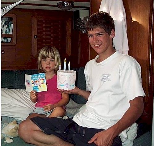
kedging off we celebrated Maria's birthday with a paper cake and card made by
Diana and Christopher.
From Beaufort one can proceed south through the ICW or
go offshore. We chose the ICW. The wind was again from the northwest so we
were able sail all day in a channel that is only about 100 yards wide. In this
section of the ICW the anchorages are few and far between. One makes the
best of a bad situation. Our next destination on this leg was Mile Hammock
Bay. This is a dredged anchorage created by the Marines in the middle of
Camp Lejeune. As you pass along this part of the ICW you can see the
Marines over in the marshes training in order to be prepared for whatever
lunatics overseas necessiatate U.S. intervention. Christopher wondered aloud
whether one of his classmates from school was out there on the marshes:
"Hi, Anana! Be safe." When they are not using it for exercises Mile
Hammock Bay is available for
civilians. Mile Hammock Bay was the site of our second grounding. We
followed the navigational aids inside then turned to where I thought there
should be water. OOOooops. Christopher and I had to load the anchor
into the dinghy so I could row it over to deep water. We then had to use
one of the winches to kedge ourselves off. While not running aground or
kedging off we celebrated Maria's birthday with a paper cake and card made by
Diana and Christopher.
Leaving Mile Hammock Bay we headed for Wrightsville
Beach. This stretch of North Carolina, south of the Marine base, is known
as the Golf Coast. The wind was again favorable so we had another
unexpected day of sailing. Wrightsville Beach has a great anchorage.
Diana and Christopher made a bee line for the beach, but didn't stay long.
A former colleague lives in the Wrightsville area. Look for George and
Joan Pidot on board MESSING ABOUT in Chesapeake Bay next summer. In
addition to sailing almost all day we also managed to not run aground in our
chosen anchorage. A red letter day for us. One of the boats we have
been traveling with was not so lucky. They went hard aground on the shoal
just north of the Wrightsville bascule bridge while waiting for it to
open.
The stretch of the ICW beyond Wrightsville Beach and
Carolina Beach is problematic. It is narrow, there are almost no
anchorages and there are very few marinas. The original plan was to go
into Dutchmans Creek just inside the southern cape of the Cape Fear River.
We got there about 1 PM, took one look and decided that we had better go
on. Dutchmans Creek was narrow, the tide was running at a couple of knots,
and there was a lot of chop from boats on the ICW. What was to be a short
day was beginning to look like a really long day. The back up anchorage
was down on the South Carolina border on the Little River which goes up to the
town of Calabash. We got to Little River at nearly 6 PM. This was
too late to find another place if we didn't like it. We didn't like
it. Another boat beat us inside so we continued on a few more hundred
yards to an option shown on the chart. Naturally it has shoaled in since
the chart was printed so we ran aground. Once again we were able to just
back off. Back up to Little River. The best spot was taken by the
boat that got in ahead of us. The 2nd, 3rd and 4th best spots were taken
up by Army Corp of Engineers dredging equipment. We headed for the 5th
best spot. Yes, for the second time in 20 minutes we were aground.
This time we couldn't back off so had to go through the kedging routine again.
We kedged off, set the anchor, cooked and ate all in the dark, and before the
tide caught us aground. Early in the morning, 5 AM, I heard an unpleasant
sound. Yes, we were aground while at anchor. In disbelief I checked
the depth sounder, which is mounted just ahead of the keel. It said 9
feet; more than enough. But the way we were laying to the wind and current
advised otherwise. Using our little handheld depth sounder I checked the
depth at the stern. Sure enough, there was only 4 feet of water.
Shortening the anchor rode solved the problem while the tide came in.
A few words about Little River for those headed
south. It is only marginally better than Dutchmans Creek. The
channel marks are nearly on the banks of the creek, so wherever you anchor you
will be in the channel. The bend in the creek opposite the golf club is
shoal so you can't go in too far. The cruising guides suggest the other
side of the ICW away from Calabash. Here too the channel marks are set
right out to the banks of the creek, leaving little anchoring room. Beyond
that, there are some dinner cruise boats of about 75 feet that go through there
after dark. Our advice is to bite the bullet and get a marina in this
stretch of the ICW.
We beat a hasty retreat out of Little River in the
morning and headed for Barefoot Landing. This is a mega mall on the ICW
with a courtesy bulkhead about 1000 feet long. In addition to the Barefoot
Princess, one of those fake paddlewheelers, and three derelict boats that seem
to have taken up residence on the bulkhead, we counted 25 boats spending the
night. For those using a road map to follow our progress this area is
behind North Myrtle Beach, SC. From Barefoot Landing it is a short walk
out to the beach. Diana, Maria and I went over to splash around for a
while.
 |
Get out your magnifying glass. Those are cable cars
taking golfers across the ICW just south of Barefoot Landing. And
you thought that the teleferique was only for the Alps. |
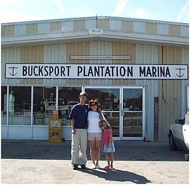
After leaving Barefoot Landing we had a short trip down
to Bucksport, SC. We made this stop for two reasons. First, there is
the family heritage thing. The founder of Bucksport, SC is the grandson of
the founder of Bucksport, ME so you could say we are cousins to any Buck family
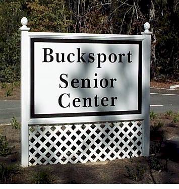
members still in either place. Today Bucksport, SC is just a bend in the
Waccamaw River, but what a beautiful bend in the river. It consists of the
Bucksport Plantation Marina, a senior citizens center, a few houses, and the
regional waste water treatment plant. Legrand Weaver, the marina owner, is
a nugget. If you're on the ICW anchor behind the red 36 and give him a
visit. Also, buy some of the local sausage; it's great.
 |
 |
 |
| This is the best side of the marina, although the owner is
having the docks rebuilt at this time. |
|
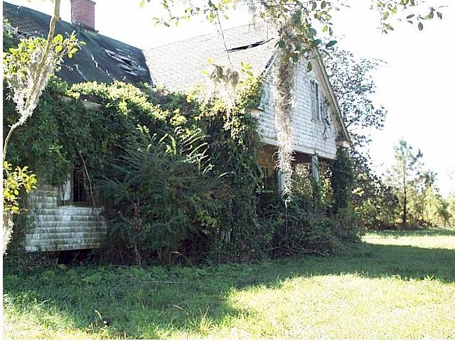
No, this isn't the senior center. It is the remains of
the house adjacent to the marina. 100 years ago there were three
lumber mills here, now this is about all that's left. There is a
Henry Buck IV over in Buckville where there is a graveyard with many of
our relatives in it. According to Mr. Weaver the most recent is from
about 1900. |
The second reason for staying in Bucksport was so that
we would have a short run to Georgetown the next day. We felt it was
important to get to Georgetown early so that we could find a place in a
reportedly crowded anchorage. Georgetown, SC is another treat. To
begin with, they do a special "trick or treat" affair on Halloween for
the kids. At the square on Harborwalk the local dance troupe did a special
performance for the kids. Then all the kids went trick or treating at all
of the merchants in town. In addition, Georgetown has a large number of
beautiful homes on the Historical Register. It was well worth timing our
trip so that we could be here for Halloween.
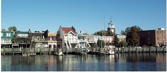
| Georgetown is a picturesque place, from this angle.
The stores now front onto the harbor and also onto the street. There
is a harbor walk that runs the length of all the shops, about half of
which are shown here. |
 |
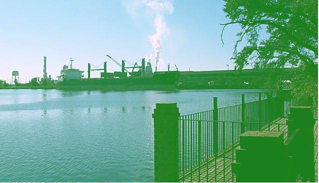 |
But 200 hundred yards from where I took the tourist brochure
photo I snapped this photo of the steel mill and ship. Having lived
in Bethlehem, PA 30 years ago I can say that this mill is much cleaner
than the one that was so dear to my heart for four years. |
To keep Diana, age 6, moving forward we have had to
build in certain inducements: The visit with her cousin Valerie in D.C., the
visit with her friend AnnaRuth in New Bern, Halloween in Georgetown. The
next inducement is a visit with her Grandparents (you're being given
forewarning, you better make it to Florida while we're there) and a side trip to Disney World.
After leaving Georgetown our path took us down Winyah
Bay and into the Low Country of South Carolina. Much of this leg of the
trip was through salt marsh. On either side of the creeks and land cuts
are flats of marsh grass almost as far as you can see. We actually had the genoa
unfurled for about 30 minutes today. Which brings us to Whiteside Creek,
about 17 miles north of Charleston. This is actually a rather good
anchorage. It is a side channel in which there is plenty of water and room
to swing, although there wouldn't be much protection from the wind in a blow.
We've made it to Charleston, SC. Maria is going
back to Philly for a week to go to work. Diana is going with her.
Christopher and I will take the boat off shore for the 165 miles to Fernandina
Beach, Florida. Using the inside route takes about 250 miles to cover the
same distance and I've about had it with the endless motoring; remember, our top
speed is about 8 MPH; you can jog that fast.
The ICW has shown us a new face almost every day:
cypress swamps replete with Spanish moss, marsh lands, luxury homes, crashing surf glimpsed through the
inlets, mile after mile of private finger piers, dense forest, water the color
of coffee from tree tannin, mile after mile of golf courses, locks, swing
bridges, a pontoon bridge. The ICW has many beauties all its own.
If you took
all of the golf courses from the Golf Coast in NC and the Grand Strand in SC and
stretched them out so that the holes and courses lay end to end then you could
probably drive a golf cart from Norfolk to Miami, and still get there before
your typical sailboat.
On this voyage we've traveled 900 miles in 47 days, just
under 20 miles per day. Our little diesel has logged about 185 hours and
used nearly 100 gallons of fuel. We've spent more days under power than
under sail; but those days under sail have been glorious.